Hydraulic Engineering
Measure
Test
Assess
Monitor

Non-destructive probing

Unexpected structural weaknesses, unknown voids and subsurface structures have a significant impact on the condition of hydraulic engineering protection structures. The stability and functionality of such installations can only be guaranteed if they are maintained and monitored at regular intervals. Ground penetrating radar (GPR) and in-situ methods can be used to non-destructively inspect these protective structures and subsequently prevent human as well as economic disasters.

Ground penetrating radar and geoelectrics

Hydraulic engineering protection systems as well as the detection of the groundwater level can be reliably monitored using ground penetrating radar and geoelectrics.

Ground penetrating radar is used as a non-invasive method for geological and geotechnical investigations, e.g. for dyke monitoring and flood protection, as well as for technical investigations of contaminated sites.

Geoelectrics is mainly used for groundwater exploration and the search for contaminated sites.

The solution

Due to the vertical and horizontal delineation, a plan representation in GIS and CAD in 2D as well as 3D is possible without time-consuming excavation work. This presentation provides decision-makers with a basis for accurate cost and budget planning. In this way, statements regarding the groundwater horizon and any damaged areas in the dam can be evaluated.

Your benefits

Dam survey
Non-destructive recording of the structure or subsoil
fast documentation
preservation of the building fabric due to less drilling
Quantitative assessment of groundwater reservoirs
decision-making basis for exact cost and budget planning
highly accurate visualization of the internal structures of building components
Groundwater monitoring and mapping of contaminated sites
Protection of soil organisms and natural habitat

Dam survey

With the help of the measurement results, dam surveying can provide information about different horizontal compaction areas, disturbances due to construction work (partial excavation for laying pipes) as well as groundwater levels.

Bridge inspection

Special attention is paid to the mapping of reinforcement structures. Objects with a size of up to ~ 1 cm can be quickly recorded with a high degree of detail and accuracy. This allows damage to the reinforcement structures such as corrosion and deformation to be analyzed in detail.

Geological mapping

Geological mapping, i.e. the systematic area-wide exploration and description of geological conditions, provides fundamental knowledge about the geological structure and the existing rock deposits of an area under investigation. The results of geological mapping are presented in the form of geological maps, for example.

Groundwater monitoring

By simultaneously exploring and mapping an area, precise information can be obtained on the position and depth of groundwater-bearing strata. The non-destructive investigation of geological structures is possible up to a depth of 100 m and more.

FAQs

What depths of investigation are possible with ground penetrating radar?
The penetration depth of the electromagnetic wave depends strongly on the local ground properties. The values were calculated based on the assumption of a normal geological environment.
The maximum penetration depth is based on perfect radar conditions, such as fresh water/ice, limestone, dry sand, concrete, etc. Depths vary greatly with the water content of the medium. 
How large can the objects to be detected be?
The smallest possible object size depends on the measurement frequency used. The choice of frequency range is a compromise between possible penetration depth and resolving capacity. Objects as small as 1 cm can be detected with the ground penetrating radar systems used by Geoprospectors.
Is corridor damage to be expected?
No. Since the ground penetrating radar is pulled over the ground and the antenna is mounted on a special plastic plate, there is no need to worry about asphalt roads being damaged, for example.
Due to the low weight of our ground penetrating radar antenna, the vegetation is only compressed for a short time and then recovers quickly.
Does the road have to be closed for the measurement work?
No, measurement can take place in flowing traffic. The measurement system used for road surveys can be mounted on a passenger car and the measurement be performed at speeds of up to 80 km/h.
What is the advantage of a Step Frequency Radar system?
The advantage of a Step Frequency Radar system compared to conventional Pulsed Radar systems is that not only one center frequency is used, but the whole frequency spectrum from 3 Ghz to about 50 Mhz is scanned during one measurement. This ensures that strata boundaries or objects in the   near-surface area as well as in the deeper layers are detected.
In which format can the data be delivered?
Depending on customer requirements, the data can be provided starting from raw data up to a GIS-compatible data exchange format.
How long does the data evaluation take?
The duration of the data evaluation depends primarily on the customer's requirements. The more extensive the end product, the longer the evaluation. Roughly speaking, one day of data collection requires one to three days of data evaluation.
The following graphic is a representation of the signal penetration depth for different materials.
The equipment used must be individually adjusted, depending on the nature of the substrate (single channel - multi-channel - radar) to achieve an optimal result.
What are the costs for the different mapping methods?

Da die Vermessungsanforderungen meist unterschiedlich sind, trifft dies auch auf die Kosten zu. Folgende Parameter müssen bei der Erstellung eines Offerts in Betracht gezogen werden:

  • Größe und Beschaffenheit des zu vermessenden Gebiets
  • Verwendetes Equipment (Einkanal-/Mehrkanal-Radar)

Gerne beraten wir Sie und stellen Ihnen ein maßgeschneidertes Angebot unter Berücksichtigung Ihrer individuellen Bedürfnisse zusammen. Wir freuen uns auf Ihre Anfrage unter office@geoprospectors.com.

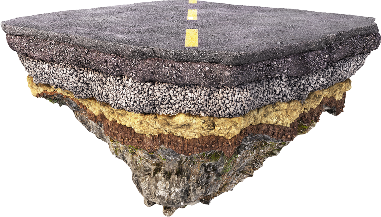
Ein Kalkulationsbeispiel auf Grundlage der Kartierung von 200 m Straßenzug im besiedelten Raum:

Kosten Equipment € 713,06
Kosten Vorbereitung € 877,29
Datenauswertung € 2.129,81
Gesamtkosten € 3.720,16

References (excerpt)

Are you interested in our hydraulic engineering solutions?
Send us your request!

Further applications:

Agriculture
Infrastructure
Turf sports
Development
Fruit growingand viniculture
© 2022 Geoprospectors GmbH. All rights reserved
bookmarkchevron-down
linkedin facebook pinterest youtube rss twitter instagram facebook-blank rss-blank linkedin-blank pinterest youtube twitter instagram